Yeah… it’s not going away. But now the confidence is growing.

URGENT – WINTER WEATHER MESSAGE National Weather Service Twin Cities/Chanhassen MN 442 PM CDT Mon Apr
8 2019 …VERY IMPACTFUL WINTER STORM EXPECTED LATER THIS WEEK… . A Winter Storm Watch has been expanded farther to the northeast for Wednesday evening through Friday afternoon. The watch now includes areas north of a line from St. James, to Faribault, and RedWing in Minnesota, and from Prescott, to Menomonie, and Chippewa Falls in west central Wisconsin. This includes all of the TwinCities metro area. A significant winter storm system is possible across a large part of the Upper Midwest starting Wednesday evening, and lasting through Friday afternoon. Light precipitation will begin to develop late Tuesday night, and into Wednesday morning in far southern Minnesota. A mixture of snow and rain will occur in far southern Minnesota, with little or no snowfall expected. Any snow that falls Wednesday morning will likely partially meltduring the day. By late Wednesday afternoon, and into Thursday night, thisis when the bulk of the precipitation will fall across southern Minnesota, and into west central Wisconsin. Confidencesthat a band of moderate to heavy snow will likely arrive Wednesday evening and continue through Thursday. Snowfall has increasedrates of 1 to 2 inches per hour will be possible at times. Winds will increase Wednesday night as the system lifts northeastward. Winds will likely gust to 40 to 50 mph on Thursday. This will lead to areas of blowing and drifting snow. Blizzard conditions will be possible. In addition, periodsof mixed precipitation of rain, and sleet will be possible at times, mainly in southern Minnesota. Snowfall will taper off andwinds should subside Friday. Additional updates to this Winter Storm Watch is possible,with the watch possibly expanding farther south or north. This is dependent on the exact track of the storm.Mille Lacs-Kanabec-Stearns-Benton-
Sherburne-Isanti-Chisago-
Wright- Hennepin-Anoka-Ramsey-
Washington-Carver-Scott-
Dakota-Le Sueur- Rice-Watonwan-Blue Earth-Polk-Barron-Rusk-St. Croix-Pierce-Dunn- Chippewa- Including the cities of Princeton, Mora, St Cloud, Foley, Elk River, Cambridge, Center City, Monticello, Minneapolis, Blaine, St Paul, Stillwater, Chaska, Shakopee, Hastings, Le Sueur, Faribault, St James, Mankato, Osceola, Rice Lake, Ladysmith, Hudson, River Falls, Prescott, Menomonie, and Chippewa Falls 442 PM CDT Mon Apr 8 2019 …WINTER STORM WATCH IN EFFECT FROM WEDNESDAY EVENING THROUGH FRIDAY AFTERNOON… * WHAT…Heavyprecipitation possible. Total snow accumulations of 7 to 15 inches. Winds could gust as high as 50 mph. * WHERE…Portions of northwest and west central Wisconsinand central , east central and south central Minnesota. * WHEN…From Wednesday evening through Friday afternoon. * ADDITIONAL DETAILS…Travel could be very difficultto impossible . Areas of blowing snow could significantlyreduce visibility . The hazardous conditions could impact themorning or evening commutes. PRECAUTIONARY/PREPAREDNESS ACTIONS… A Winter Storm Watch means there is potential for significant snow, sleet or ice accumulations that may impact travel. Continue to monitor the latest forecasts. &&Stevens-Pope-Lac Qui Parle-Swift-Chippewa-
Kandiyohi-Meeker- Yellow Medicine-Renville-McLeod-Sibley-Redwood-Brown-Nicollet- Including the cities of Morris, Glenwood, Madison, Benson, Montevideo, Willmar, Litchfield, Granite Falls, Olivia, Hutchinson, Gaylord, Redwood Falls, New Ulm, and St Peter 442 PM CDT Mon Apr8 2019 …WINTER STORM WATCH REMAINS IN EFFECT FROM WEDNESDAY EVENING THROUGH FRIDAY AFTERNOON… * WHAT…Blizzardconditions possible. Total snow accumulationsof greater than 8 inches possible along with widespread blowingand drifting snow. Winds could gust as high as 55 mph. * WHERE…Portions of central,south central , southwest andwest central Minnesota. * WHEN…From Wednesday evening through Friday afternoon. * ADDITIONAL DETAILS…Travel could be very difficultto impossible . Areas of blowing snow could significantlyreduce visibility . The hazardous conditions could impact themorning or evening commute. PRECAUTIONARY/PREPAREDNESS ACTIONS… A Winter Storm Watch for blizzard conditions means there is a potential for falling and/or blowing snow with strong winds and extremely poor visibilities. This can lead to whiteout conditions and make travel very dangerous.
So here is where we are at right now. It appears like it could start Wednesday morning and run through Friday.

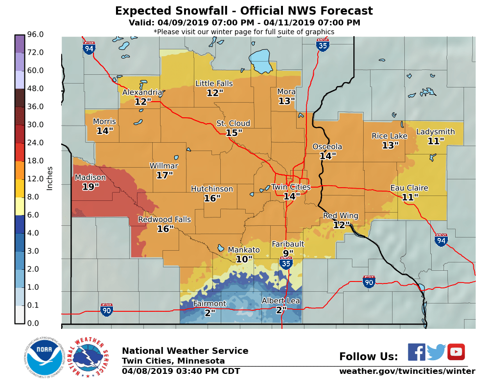
Sometimes rates will be a couple of inches an hour. The totals are harder to pin down. The NWS is saying the Mankato area could get around 10 inches of snow.
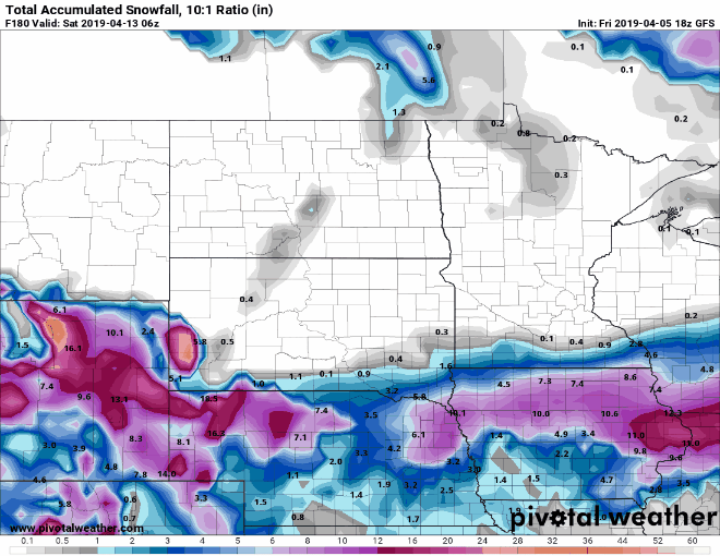
Looking to Windy, the European Model is saying close to 19 inches.

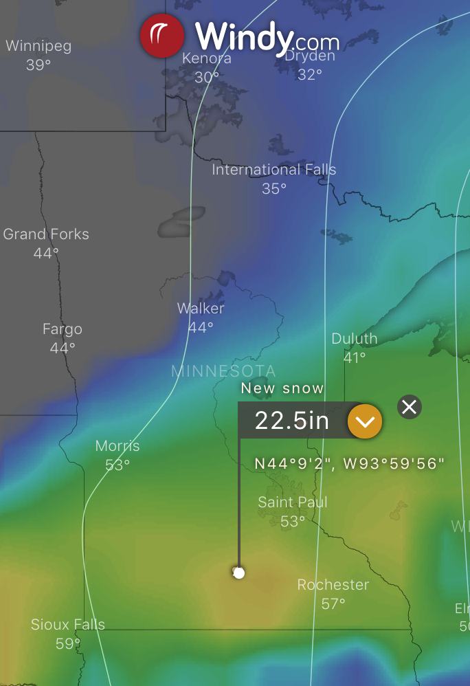
The GFS in Windy is showing closer to 22.5.
Let’s pull out my standard GFS models as well showing between 18 and 21 inches of snow.


Just to give you an idea of what we are dealing with, there is a system with a significant amount of precipitation. The models are showing that we will be getting around 2.1 inches of water falling.

Watching KSTP right now, they are saying the system is going to go further north giving us about 2-3 inches of snow. I am questioning this. What is posted here is the latest models, they are NOT showing this.
We need to remember, with the news cycle, meteorologists are working with data that could be up to 6 hours old (or more). They are also trying to predict the track of the system. These models also do that and looking at the trends, it hasn’t moved much since the first couple of models.
So, on to my prediction. I am not convinced that we will get 20+ inches of snow. I am sure we are getting a lot of snow. I am hoping for more rain than snow, but I’m not so sure about that.
The next thing, temperatures.
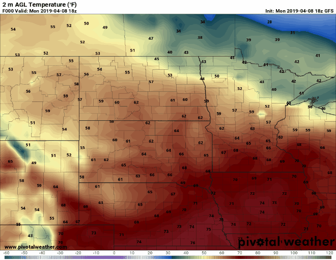
Even though the temps are above freezing, there are good cold temps in the upper atmosphere giving it a good chance of wet nasty snow.
We are also close to the edge for a chance of thunderstorms with this system.
Thunder + Snow = THUNDERSNOW!
That is all I’m going to write for now. Probably the longest post so far. But I want to show that this is very powerful and complicated this system is.
As always, stay safe and be weather aware!
No responses yet